Fichier:Yonaguni Island Aerial photograph.2012.jpg

Taille de cet aperçu : 800 × 367 pixels. Autres résolutions : 320 × 147 pixels | 640 × 293 pixels | 1 024 × 469 pixels | 1 280 × 587 pixels | 2 560 × 1 173 pixels | 6 546 × 3 000 pixels.
Fichier d’origine (6 546 × 3 000 pixels, taille du fichier : 14,16 Mio, type MIME : image/jpeg)
Description
| Description |
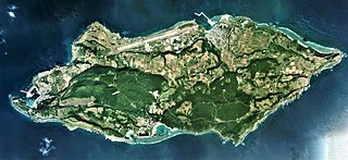
日本語: 与那国島(沖縄県八重山郡与那国町)の空中写真。COK20122-C3-1から同7、同C4-1から同7、同C5-1から同8、同C6-1から同9、同C7-1から同9、同C8-2から同10、同C9-2から同10、同C10-2から同10、同C11-2から同10、同C12-1から同9、同C13-1から同9、同C14-1から同9、同C15-1から同9、同C16-1から同8、同C16-1から同8、同C17-1から同8、同C18-1から同5の合計119枚を合成作成。
English: Yonaguni Island Aerial photograph.2012 |
| Date | |
| Source | 国土情報ウェブマッピングシステム |
| Auteur | 国土地理院 |
Conditions d’utilisation

|
Le détenteur des droits d’auteur de ce fichier, Ministère du Territoire, des Infrastructures, des Transports et du Tourisme, autorise n’importe qui à l’utiliser pour n’importe quelle utilisation, pourvu que le détenteur des droits d’auteur soit correctement attribué. La redistribution, les œuvres dérivées, l’utilisation commerciale et toutes les autres utilisations sont autorisées. |
Attribution:
Copyright © National Land Image Information (Color Aerial Photographs), Ministry of Land, Infrastructure, Transport and Tourism
|
 |
This image is copyrighted by the Ministry of Land, Infrastructure, Transport and Tourism of Japan. For terms of use, see the stipulation to use of National Land Information (in Japanese) and message from MLIT (in Japanese and English). When you display this image on an article, include the following phrase in the description: "Made based on National Land Image Information (Color Aerial Photographs), Ministry of Land, Infrastructure, Transport and Tourism".
|
Historique du fichier
Cliquer sur une date et heure pour voir le fichier tel qu'il était à ce moment-là.
| Date et heure | Vignette | Dimensions | Utilisateur | Commentaire | |
|---|---|---|---|---|---|
| actuel | 6 novembre 2020 à 06:07 | | 6 546 × 3 000 (14,16 Mio) | さかおり | Uploaded a work by 国土地理院 from 国土情報ウェブマッピングシステム with UploadWizard |
Utilisation du fichier
La page suivante utilise ce fichier :
Usage global du fichier
Les autres wikis suivants utilisent ce fichier :
- Utilisation sur eu.wikipedia.org
- Utilisation sur he.wikipedia.org
- Utilisation sur incubator.wikimedia.org
- Utilisation sur it.wikivoyage.org
- Utilisation sur ja.wikipedia.org
- Utilisation sur www.wikidata.org
- Utilisation sur zh.wikipedia.org