Fichier:St. John, U.S. Virgin Islands.jpg

Taille de cet aperçu : 600 × 600 pixels. Autres résolutions : 240 × 240 pixels | 480 × 480 pixels | 768 × 768 pixels | 1 024 × 1 024 pixels | 2 400 × 2 400 pixels.
Fichier d’origine (2 400 × 2 400 pixels, taille du fichier : 2,74 Mio, type MIME : image/jpeg)
Description
| Description |
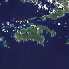
English: Natural-colour image of the Island of St. John island in the United States Virgin Islands.
|
| Date | |
| Source | NASA Earth Observatory |
| Auteur | Jesse Allen and Robert Simmon |
| Autres versions |


.jpg)

Image captured by the Advanced Land Imager (ALI) on NASA’s Earth Observing-1 (EO-1) satellite. EO-1 ALI data provided courtesy of the NASA EO-1 team.
Conditions d’utilisation
| Ce fichier provient de la NASA. Sauf exception, les documents créés par la NASA ne sont pas soumis à copyright. Pour plus d'informations, voir la politique de copyright de la NASA. | ||
 |
Attention :
|
| Annotations | Cette image est annotée : Voir les annotations sur Wikimedia Commons |
Historique du fichier
Cliquer sur une date et heure pour voir le fichier tel qu'il était à ce moment-là.
| Date et heure | Vignette | Dimensions | Utilisateur | Commentaire | |
|---|---|---|---|---|---|
| actuel | 20 janvier 2011 à 10:13 | | 2 400 × 2 400 (2,74 Mio) | Originalwana | {{Information |Description={{en|1=Natural-colour image of the eastern half of St. John. Settlements—marked by curving roads and light roofs—line the irregular coastline. The pinpoints of white in Coral Bay are probably boats. The island’s interior |
Utilisation du fichier
La page suivante utilise ce fichier :
Usage global du fichier
Les autres wikis suivants utilisent ce fichier :
- Utilisation sur arz.wikipedia.org
- Utilisation sur ast.wikipedia.org
- Utilisation sur ca.wikipedia.org
- Utilisation sur ceb.wikipedia.org
- Utilisation sur cy.wikipedia.org
- Utilisation sur en.wikipedia.org
- Utilisation sur en.wikisource.org
- Utilisation sur eo.wikipedia.org
- Utilisation sur es.wikipedia.org
- Utilisation sur eu.wikipedia.org
- Utilisation sur fi.wikipedia.org
- Utilisation sur frr.wikipedia.org
- Utilisation sur gl.wikipedia.org
- Utilisation sur id.wikipedia.org
- Utilisation sur lb.wikipedia.org
- Utilisation sur pl.wikipedia.org
- Utilisation sur tg.wikipedia.org
- Utilisation sur tl.wikipedia.org
- Utilisation sur uk.wikipedia.org
- Utilisation sur vec.wikipedia.org
- Utilisation sur www.wikidata.org