Fichier:Kudaka Island,Nanjo.jpg

Taille de cet aperçu : 800 × 392 pixels. Autres résolutions : 320 × 157 pixels | 640 × 314 pixels | 1 024 × 502 pixels | 1 280 × 628 pixels | 2 560 × 1 256 pixels | 5 300 × 2 600 pixels.
Fichier d’origine (5 300 × 2 600 pixels, taille du fichier : 4,07 Mio, type MIME : image/jpeg)
Description
| Description |
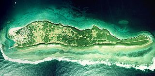
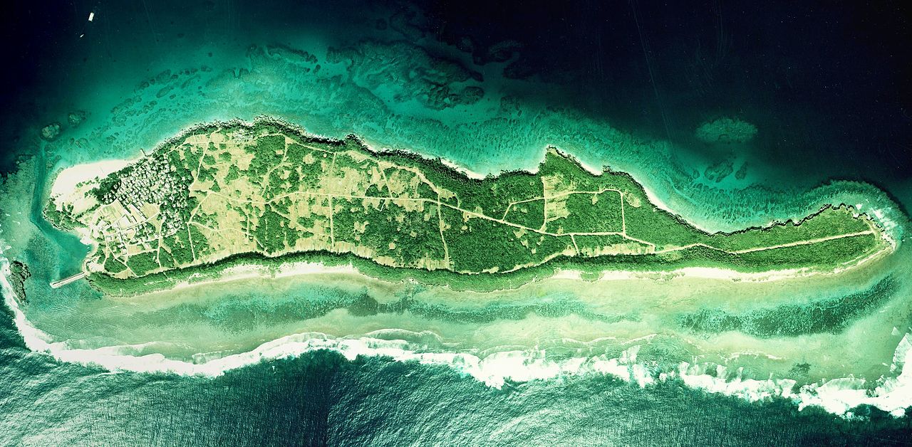
English: Kudaka Island, Nanjo, Okinawa, Japan.
日本語: 久高島(沖縄県南城市)
国土交通省の国土画像情報(カラー空中写真)を元に作成。
|
| Date | |
| Source | COK-77-1-C87-6, COK-77-1-C87-7, COK-77-1-C87-8 |
| Auteur |
English: Geospatial Information Authority of Japan
日本語: 国土地理院 |
| Lieu de la prise de vue | | Voir cet endroit et d’autres images sur : OpenStreetMap |
|---|
| Cette image a été retouchée, ce qui signifie qu'elle a été modifiée par ordinateur et est différente de l'image d'origine. Liste des modifications : Combined 3 aerial photos and cropped. Modifications effectuées par Kugel~commonswiki.
|
Conditions d’utilisation

|
Le détenteur des droits d’auteur de ce fichier, Ministère du Territoire, des Infrastructures, des Transports et du Tourisme, autorise n’importe qui à l’utiliser pour n’importe quelle utilisation, pourvu que le détenteur des droits d’auteur soit correctement attribué. La redistribution, les œuvres dérivées, l’utilisation commerciale et toutes les autres utilisations sont autorisées. |
Attribution:
Copyright © National Land Image Information (Color Aerial Photographs), Ministry of Land, Infrastructure, Transport and Tourism
|
 |
This image is copyrighted by the Ministry of Land, Infrastructure, Transport and Tourism of Japan. For terms of use, see the stipulation to use of National Land Information (in Japanese) and message from MLIT (in Japanese and English). When you display this image on an article, include the following phrase in the description: "Made based on National Land Image Information (Color Aerial Photographs), Ministry of Land, Infrastructure, Transport and Tourism".
|
Historique du fichier
Cliquer sur une date et heure pour voir le fichier tel qu'il était à ce moment-là.
| Date et heure | Vignette | Dimensions | Utilisateur | Commentaire | |
|---|---|---|---|---|---|
| actuel | 20 mars 2017 à 06:27 | | 5 300 × 2 600 (4,07 Mio) | Kugel~commonswiki | Combined photos using by stitching software |
| 17 octobre 2013 à 08:44 | 5 529 × 1 185 (2,36 Mio) | Kugel~commonswiki | renewal | ||
| 31 mars 2010 à 10:50 |  | 5 425 × 2 921 (1,88 Mio) | Kugel~commonswiki | {{Information |Description={{en|1=Kudaka Island, Nanjo, Okinawa, Japan.}} {{ja|1=久高島(沖縄県南城市)}} |Source=Japanese Ministry of Land, Infrastructure, Transport and Tourism[http://w3land.mlit.go.jp/cgi-bin/WebGIS2/WC_AirPhoto.cgi?IT=p&DT= |
Utilisation du fichier
Aucune page n’utilise ce fichier.
Usage global du fichier
Les autres wikis suivants utilisent ce fichier :
- Utilisation sur cs.wikipedia.org
- Utilisation sur ja.wikipedia.org
- Utilisation sur zh.wikipedia.org