Fichier:ISS-20 Caribbean island of Hispaniola from the ISS.jpg
Taille de cet aperçu : 800 × 532 pixels. Autres résolutions : 320 × 213 pixels | 640 × 426 pixels | 1 024 × 681 pixels | 1 280 × 852 pixels | 2 560 × 1 703 pixels | 4 256 × 2 832 pixels.
Fichier d’origine (4 256 × 2 832 pixels, taille du fichier : 1,17 Mio, type MIME : image/jpeg)
Description
| Description |
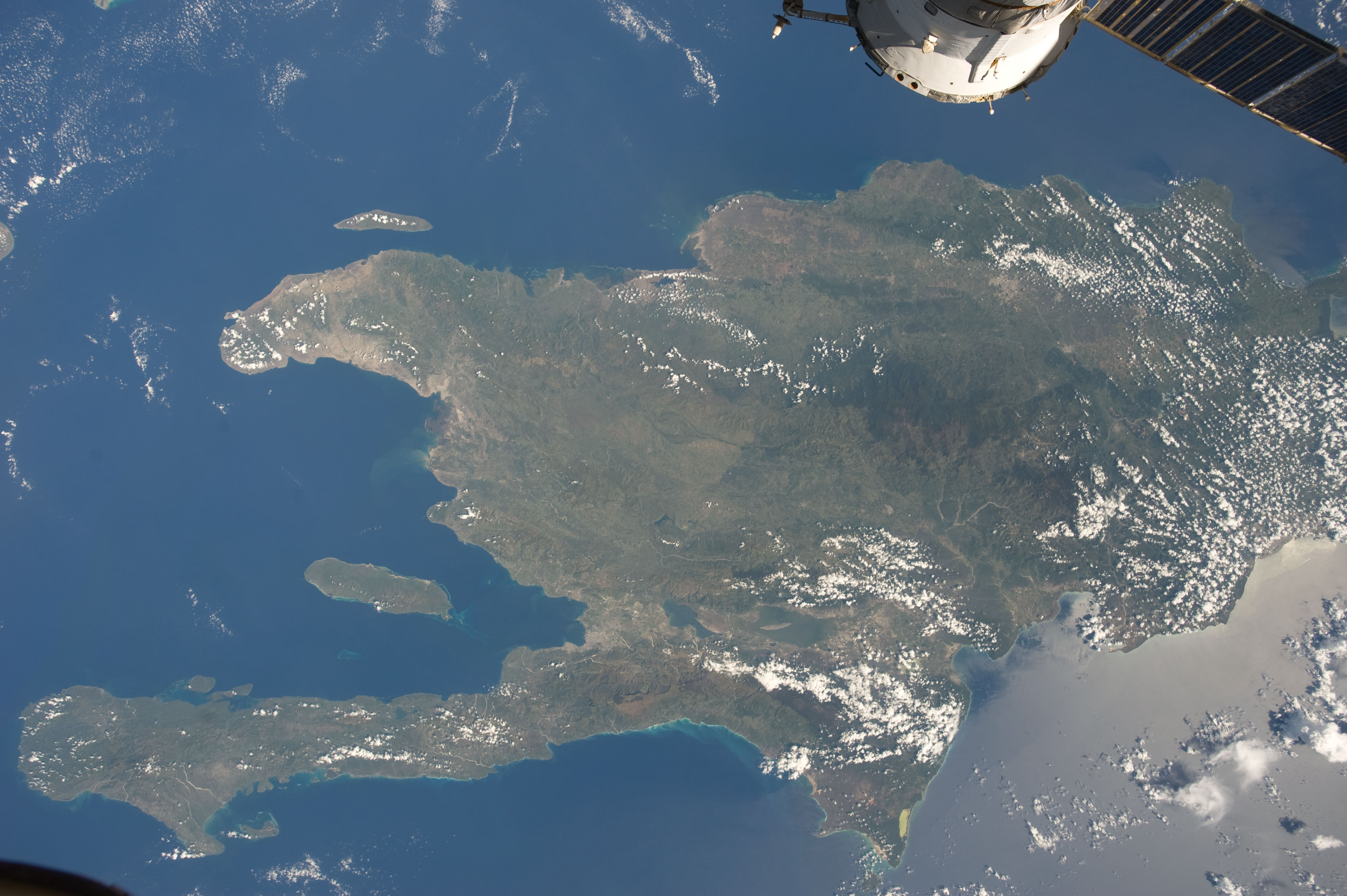
English: A view of the Caribbean island of Hispaniola from the International Space Station. This island is comprised of Haiti (in the center left of the image) and the Dominican Republic and is part of the Greater Antilles island chain which lies along the geological border of the North America Plate and the Caribbean Plate. A major fault line in the region, Enriquillo-Plantain Garden Fault, runs along the longer peninsula, in the foreground, and just south of Port-au-Prince. Part of a docked Russian spacecraft can be seen in the foreground. The epicenter of the disastrous 2010 earthquake occurred near this fault. This image was taken by the Expedition 20 crew on the International Space Station on Sept. 28, 2009 using a 25 mm lens setting. |
| Date | |
| Source | http://spaceflight.nasa.gov/gallery/images/station/crew-20/html/iss020e043301.html |
| Auteur | NASA/Expedition 20 crew |
| Autres versions |
Cette image ou vidéo a été cataloguée par le Johnson Space Center de la National Aeronautics and Space Administration (NASA) des États-Unis sous Photo ID : ISS020-E-043301.Ce bandeau n’indique rien sur le statut de l’œuvre au regard du droit d'auteur. Un bandeau de droit d’auteur est requis. Voir Commons:À propos des licences pour plus d’informations. Autres langues :
|
Conditions d’utilisation
| Ce fichier provient de la NASA. Sauf exception, les documents créés par la NASA ne sont pas soumis à copyright. Pour plus d'informations, voir la politique de copyright de la NASA. | ||
 |
Attention :
|
Historique du fichier
Cliquer sur une date et heure pour voir le fichier tel qu'il était à ce moment-là.
| Date et heure | Vignette | Dimensions | Utilisateur | Commentaire | |
|---|---|---|---|---|---|
| actuel | 22 juin 2012 à 20:18 | | 4 256 × 2 832 (1,17 Mio) | Ras67 | {{Information |Description={{en|1=A view of the Caribbean island of Hispaniola from the International Space Station. This island is comprised of Haiti (in the center left of the image) and the Dominican Republic and is part of the Greater Antilles isla... |
Utilisation du fichier
La page suivante utilise ce fichier :
Usage global du fichier
Les autres wikis suivants utilisent ce fichier :
- Utilisation sur ar.wikipedia.org
- Utilisation sur ast.wikipedia.org
- Utilisation sur az.wikipedia.org
- Utilisation sur ba.wikipedia.org
- Utilisation sur ca.wikipedia.org
- Utilisation sur ceb.wikipedia.org
- Utilisation sur cy.wikipedia.org
- Utilisation sur de.wikipedia.org
- Utilisation sur es.wikipedia.org
- Utilisation sur eu.wikipedia.org
- Utilisation sur fi.wiktionary.org
- Utilisation sur ga.wikipedia.org
- Utilisation sur hsb.wikipedia.org
- Utilisation sur ht.wikipedia.org
- Utilisation sur hy.wikipedia.org
- Utilisation sur ia.wikipedia.org
- Utilisation sur lb.wikipedia.org
- Utilisation sur no.wikipedia.org
- Utilisation sur pap.wikipedia.org
- Utilisation sur pl.wikipedia.org
- Utilisation sur pnb.wikipedia.org
- Utilisation sur ro.wikipedia.org
- Utilisation sur sv.wikipedia.org
- Utilisation sur tg.wikipedia.org
- Utilisation sur uk.wikipedia.org
- Utilisation sur uz.wikipedia.org
- Utilisation sur vec.wikipedia.org
- Utilisation sur www.wikidata.org