Fichier:Piccadilly Station Manchester - geograph.org.uk - 692981.jpg
Pas de plus haute résolution disponible.
Piccadilly_Station_Manchester_-_geograph.org.uk_-_692981.jpg (800 × 534 pixels, taille du fichier : 100 kio, type MIME : image/jpeg)
Description
| Description |
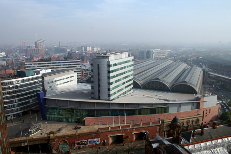
English: Piccadilly Station Manchester Store Street Station opened in 1842 as the terminus of the Manchester and Birmingham Railway. As the rail network expanded it became London Road Station in 1849. It was rebuilt and became Manchester Piccadilly in 1960 for the new London Midland Region electric service to London. The two openings visible at the bottom centre of the photograph are for the Manchester Metrolink trams which went into service in 1992. The station was extensively modified for the 2002 Commonwealth Games. |
| Date | |
| Source | From geograph.org.uk |
| Auteur | Peter Hyde |
| Attribution (imposé par la licence) | Peter Hyde / Piccadilly Station Manchester / |
| Lieu de la prise de vue | | Voir cet endroit et d’autres images sur : OpenStreetMap |
|---|
_heading:90.00&language=fr)
| Position de l'objet | | Voir cet endroit et d’autres images sur : OpenStreetMap |
|---|
_heading:90.00&language=fr)
Conditions d’utilisation

|
Cette image provient de la collection du projet Geograph British Isles. Pour obtenir les coordonnées du photographe, veuillez consulter cette page de description de l'image sur le site du projet. Les droits d'auteurs sur cette image sont détenus par Peter Hyde ; l'image est placée sous une licence Creative Commons avec mention de paternité et partage à l'identique (CC-By-SA) en version 2.0.
|
Ce fichier est disponible selon les termes de la licence Creative Commons Attribution – Partage dans les Mêmes Conditions 2.0 Générique
Attribution: Peter Hyde
- Vous êtes libre :
- de partager – de copier, distribuer et transmettre cette œuvre
- d’adapter – de modifier cette œuvre
- Sous les conditions suivantes :
- paternité – Vous devez donner les informations appropriées concernant l'auteur, fournir un lien vers la licence et indiquer si des modifications ont été faites. Vous pouvez faire cela par tout moyen raisonnable, mais en aucune façon suggérant que l’auteur vous soutient ou approuve l’utilisation que vous en faites.
- partage à l’identique – Si vous modifiez, transformez, ou vous basez sur cette œuvre, vous devez distribuer votre contribution sous la même licence ou une licence compatible avec celle de l’original.
Historique du fichier
Cliquer sur une date et heure pour voir le fichier tel qu'il était à ce moment-là.
| Date et heure | Vignette | Dimensions | Utilisateur | Commentaire | |
|---|---|---|---|---|---|
| actuel | 17 avril 2014 à 14:41 | | 800 × 534 (100 kio) | G-13114 | resized |
| 8 février 2011 à 05:44 |  | 640 × 427 (67 kio) | GeographBot | == {{int:filedesc}} == {{Information |description={{en|1=Piccadilly Station Manchester Store Street Station opened in 1842 as the terminus of the Manchester and Birmingham Railway. As the rail network expanded it became London Road Station in 1849. It was |
Utilisation du fichier
La page suivante utilise ce fichier :
Usage global du fichier
Les autres wikis suivants utilisent ce fichier :
- Utilisation sur ar.wikipedia.org
- Utilisation sur arz.wikipedia.org
- Utilisation sur be-tarask.wikipedia.org
- Utilisation sur cs.wikipedia.org
- Utilisation sur de.wikipedia.org
- Utilisation sur en.wikipedia.org
- Manchester
- North West England
- Manchester Piccadilly station
- Portal:North West England
- Transport in Manchester
- Architecture of Manchester
- List of busiest railway stations in Great Britain (2021–22)
- The Warehouse Project
- Manchester station group
- List of busiest railway stations in Great Britain (2020–21)
- List of busiest railway stations in Great Britain (2019–20)
- List of busiest railway stations in Great Britain
- Utilisation sur es.wikipedia.org
- Utilisation sur fa.wikipedia.org
- Utilisation sur he.wikivoyage.org
- Utilisation sur hu.wikipedia.org
- Utilisation sur id.wikipedia.org
- Utilisation sur it.wikivoyage.org
- Utilisation sur ja.wikipedia.org
- Utilisation sur nl.wikipedia.org
- Utilisation sur www.wikidata.org
- Utilisation sur yi.wikipedia.org
- Utilisation sur zh.wikipedia.org