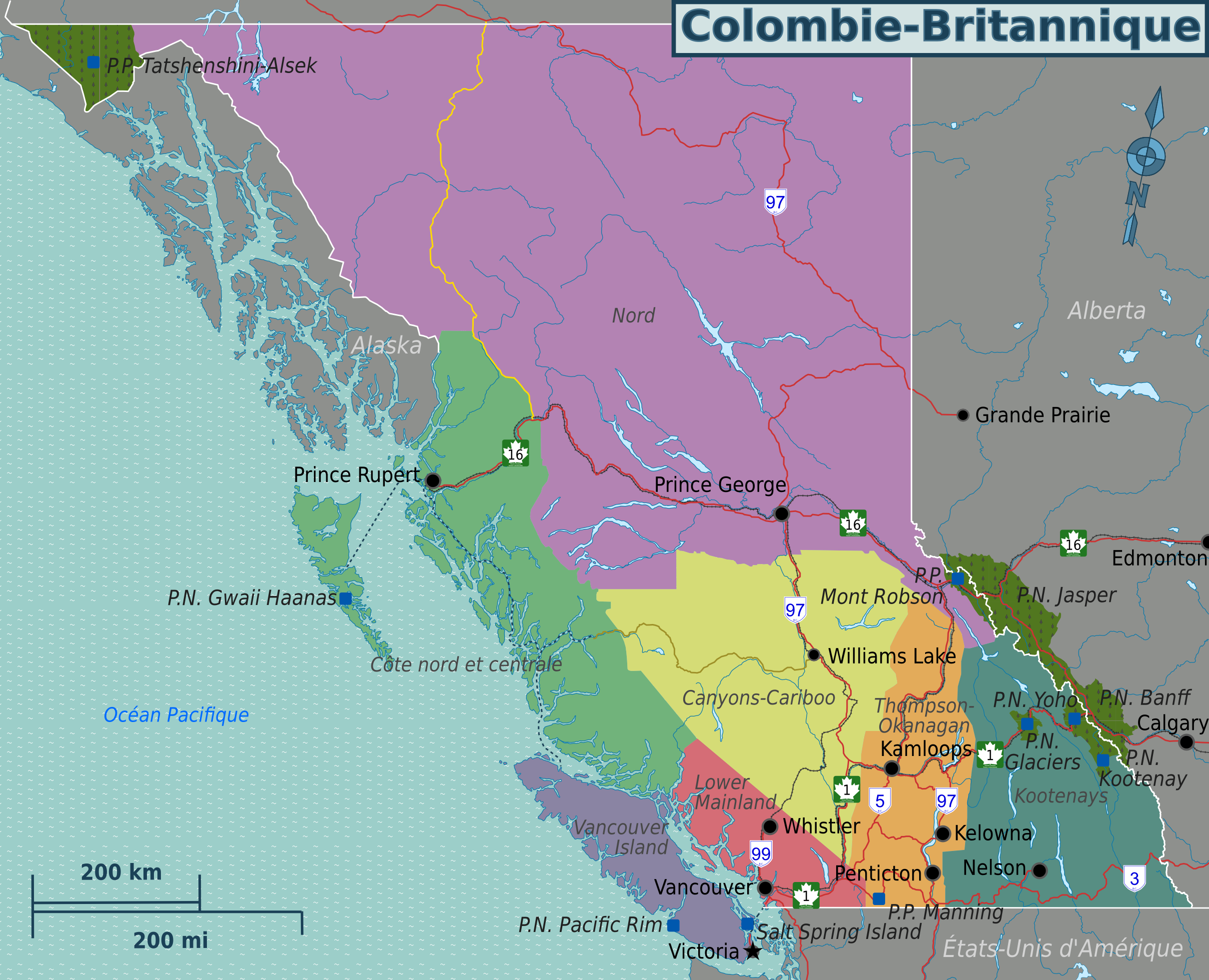
Fichier:BC regions map (fr).png
Taille de cet aperçu : 740 × 600 pixels. Autres résolutions : 296 × 240 pixels | 593 × 480 pixels | 948 × 768 pixels | 1 264 × 1 024 pixels | 2 419 × 1 960 pixels.
Fichier d’origine (2 419 × 1 960 pixels, taille du fichier : 1,42 Mio, type MIME : image/png)
.png)
Description
| Description |
English: French Wikivoyage-style map of British Columbia. |
| Date | |
| Source | File:BC regions map.svg - SVG base map for all language versions |
| Auteur | Drawn by Shaund and Joelf |
| Autres versions | File:BC regions 2010.png - English version of map |
Conditions d’utilisation
Ce fichier est disponible selon les termes de la licence Creative Commons Attribution – Partage dans les Mêmes Conditions 3.0 (non transposée).
- Vous êtes libre :
- de partager – de copier, distribuer et transmettre cette œuvre
- d’adapter – de modifier cette œuvre
- Sous les conditions suivantes :
- paternité – Vous devez donner les informations appropriées concernant l'auteur, fournir un lien vers la licence et indiquer si des modifications ont été faites. Vous pouvez faire cela par tout moyen raisonnable, mais en aucune façon suggérant que l’auteur vous soutient ou approuve l’utilisation que vous en faites.
- partage à l’identique – Si vous modifiez, transformez, ou vous basez sur cette œuvre, vous devez distribuer votre contribution sous la même licence ou une licence compatible avec celle de l’original.
Journal des téléversements d’origine
| Ce fichier a été téléversé à partir de Wikivoyage WTS. |
La page de description originale était ici. Tous les noms d'utilisateur qui suivent se rapportent à wts.wikivoyage-old.
.png)
- 2012-03-24 05:49 (WT-shared) Joelf[lien mort] 2419×1960 (1484670 bytes) {{Imagecredit|credit=Drawn by [[User:Shaund|Shaund]]|captureDate=Jan 4, 2010|location=British Columbia|source=[[:Image:BC regions map.svg]]| (Import from wikitravel.org/shared)
- 2012-03-24 05:54 (WT-shared) Joelf[lien mort] 2419×1960 (1484681 bytes) Minor fix (Import from wikitravel.org/shared)
Historique du fichier
Cliquer sur une date et heure pour voir le fichier tel qu'il était à ce moment-là.
| Date et heure | Vignette | Dimensions | Utilisateur | Commentaire | |
|---|---|---|---|---|---|
| actuel | 21 novembre 2012 à 05:38 | | 2 419 × 1 960 (1,42 Mio) | OgreBot | (BOT): Reverting to most recent version before archival |
| 21 novembre 2012 à 05:37 |  | 2 419 × 1 960 (1,42 Mio) | OgreBot | (BOT): Uploading old version of file from wts.wikivoyage; originally uploaded on 2012-03-24 05:49:10 by (WT-shared) Joelf | |
| 17 novembre 2012 à 22:41 |  | 2 419 × 1 960 (1,42 Mio) | MGA73bot2 | {{BotMoveToCommons|wts.oldwikivoyage|year={{subst:CURRENTYEAR}}|month={{subst:CURRENTMONTHNAME}}|day={{subst:CURRENTDAY}}}} == {{int:filedesc}} == {{Information |description=Map of British Columbia. PNG French version, British Columbia * Map of: Britis... |
Utilisation du fichier
La page suivante utilise ce fichier :
Usage global du fichier
Les autres wikis suivants utilisent ce fichier :
- Utilisation sur fr.wikipedia.org
.png)