Fichier:Africa independence dates.PNG

Taille de cet aperçu : 564 × 600 pixels. Autres résolutions : 226 × 240 pixels | 451 × 480 pixels | 752 × 800 pixels.
Fichier d’origine (752 × 800 pixels, taille du fichier : 42 kio, type MIME : image/png)

|
Une version vectorielle de cette image existe, dans le format « SVG ». Si elle n’est pas inférieure, elle devrait être utilisée à la place de la présente version pour des affichages en plus grandes dimensions ou nécessitant une meilleure résolution.
File:Africa independence dates.PNG → File:Africa independence dates.svg
Pour plus d’informations sur les images vectorielles, consultez la page de transition de Commons vers le format SVG. Voir aussi les informations à propos de la manière dont le logiciel MediaWiki gère les images au format SVG. |
 |
Description
Español: Fechas de independencia de los países africanos.
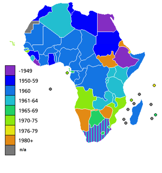
Countries of Africa, with date of independence
Conditions d’utilisation

|
Vous avez la permission de copier, distribuer et modifier ce document selon les termes de la GNU Free Documentation License version 1.2 ou toute version ultérieure publiée par la Free Software Foundation, sans sections inaltérables, sans texte de première page de couverture et sans texte de dernière page de couverture. Un exemplaire de la licence est inclus dans la section intitulée GNU Free Documentation License. |
| Ce fichier est disponible selon les termes de la licence Creative Commons Attribution – Partage dans les Mêmes Conditions 3.0 (non transposée). | ||
| ||
| Ce bandeau de licence a été ajouté à ce fichier dans le cadre de la procédure de mise à jour des licences des images sous GFDL. |
Historique du fichier
Cliquer sur une date et heure pour voir le fichier tel qu'il était à ce moment-là.
| Date et heure | Vignette | Dimensions | Utilisateur | Commentaire | |
|---|---|---|---|---|---|
| actuel | 9 juillet 2011 à 04:25 | | 752 × 800 (42 kio) | Hoshie | added South Sudan to the map |
| 19 juin 2011 à 02:34 |  | 752 × 800 (42 kio) | Muso | Reverted to version as of 10:09, 22 April 2011 | |
| 19 juin 2011 à 02:19 |  | 752 × 800 (14 kio) | Muso | Zimbabwe got his independence in 1965, therefore correct its color from orange green | |
| 22 avril 2011 à 10:09 |  | 752 × 800 (42 kio) | Hoshie | added the French departements of Mayotte and Reunion and the Ilies Eparses distict of the TAAF; CIA maps was used as a source. A version w/ Southern Sudan is ready for July. | |
| 11 avril 2011 à 03:00 |  | 752 × 800 (42 kio) | Hoshie | added Cabinda (Angola) to the map; a version with Southern Sudan is ready once they declare independence in July. | |
| 6 avril 2010 à 18:16 |  | 752 × 800 (38 kio) | Lemonade100 | De Jure Independance of Zimbawe and South Africa (changed from de facto), St Helena and dependancies added. | |
| 23 mars 2008 à 01:35 |  | 752 × 690 (36 kio) | Serg!o | UN considers Sahara as a colony - ONU considera Sahara como colonia | |
| 22 mars 2006 à 11:44 |  | 752 × 690 (36 kio) | Roke~commonswiki | Countries of Africa, with date of independence Category: Maps of Africa Category: History of Africa |
Utilisation du fichier
Aucune page n’utilise ce fichier.
Usage global du fichier
Les autres wikis suivants utilisent ce fichier :
- Utilisation sur bn.wikipedia.org
- Utilisation sur el.wikivoyage.org
- Utilisation sur en.wikipedia.org
- Utilisation sur hi.wikipedia.org